The Center for Public Engagement with Science gets North Carolinians involved in UNC-Chapel Hill research — including a unique project with NASA that educates volunteers about lakes in their own communities.
Why? That’s the main question Grant Parkins gets from community members when he explains the Lake Observations by Citizen Scientists and Satellites (LOCSS) project. Why take repeated measurements of water levels in lakes across North Carolina and beyond? His job is to explain the research in a way that not only makes sense to non-scientists but piques their interest enough to convert them into a volunteer — or citizen scientist.
“We need a scientifically literate society so we can solve the unique set of problems we are facing by using scientific solutions,” says Parkins, the Watershed Education Coordinator at the Center for Public Engagement with Science (CPES) in the UNC Institute for the Environment. “By communicating our research on things like climate change, contaminated drinking water, and the health effects of air pollution, we can inspire young people to become the next generation of scientists and educate them on the issues and policies that impact their communities.”
A passion for science communication fuels multiple programs within the center and has contributed to global growth for LOCSS. Parkins and Sarah Yelton, the environmental education and citizen science program manager at CPES, started the pilot project in 2017 with funding from NASA and direction from Tamlin Pavelsky, a hydrologist and professor within the College of Arts and Sciences who has been working with the space agency on other water-monitoring projects.
“Every natural lake is an indicator for what’s going on with the water cycle around it,” Pavelsky says. “People who live around lakes are impacted by the water levels going up and down. Yet out of the thousands and thousands of natural lakes in the U.S., maybe a few hundred are consistently monitored.”
Parkins and Pavelsky knew that by combining data on water levels with surface area measurements derived from satellite images they could understand how the volume of water in lakes changes over time. To get those in-person measurements, they turned to locals.
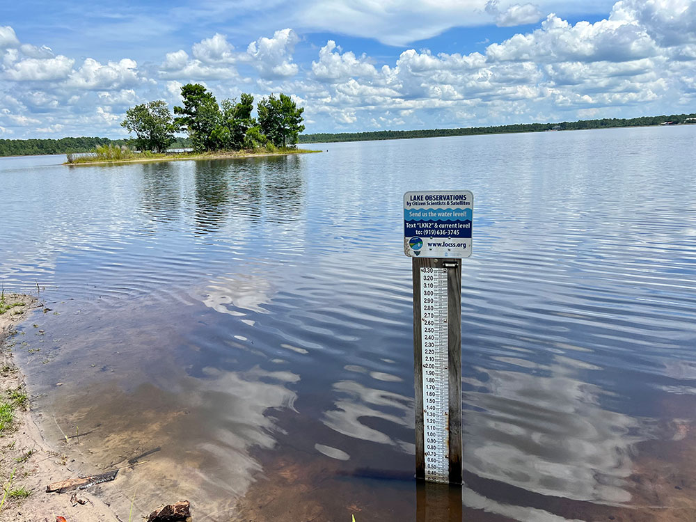
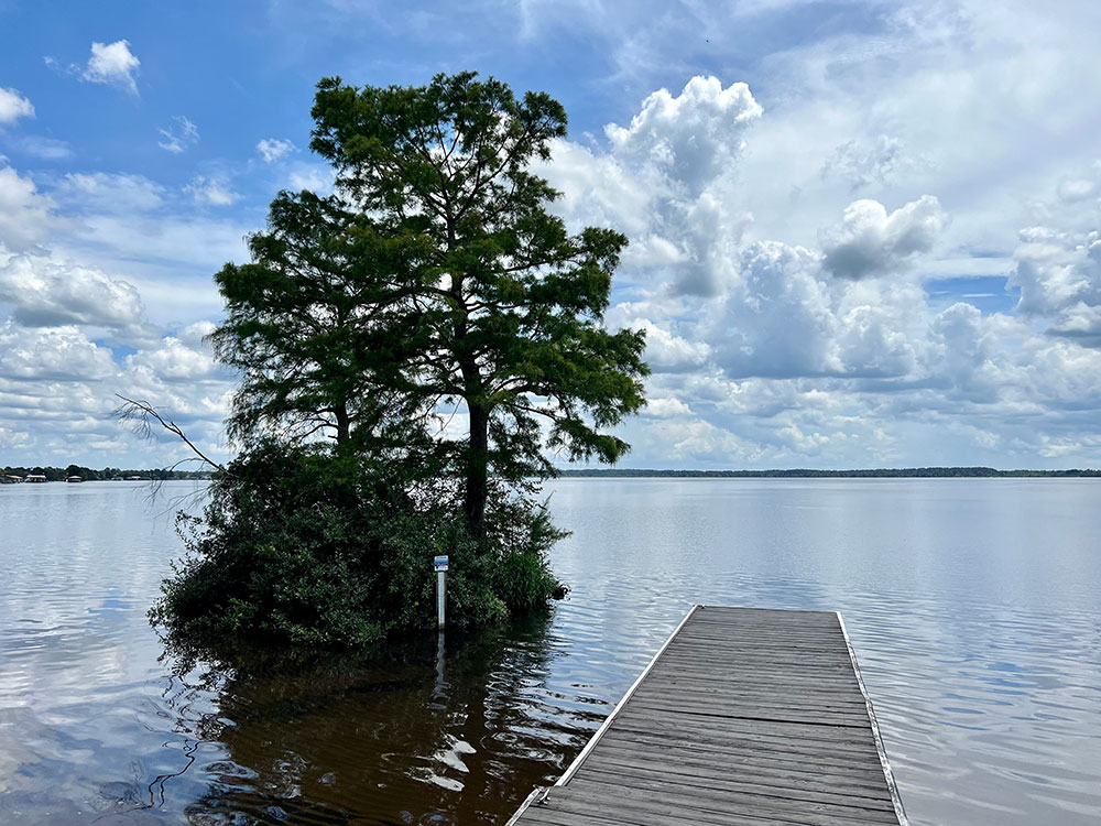
Bay Tree Lake in Bladen County, N.C., was one of the first sites for a LOCSS gauge. Similar in appearance to a giant ruler, the gauge is accompanied by a sign with an invitation to text the water level to a designated phone number — which at the time belonged to Parkins.
“I would receive a text message with water level measurements, manually enter the data into our website, and personally respond to the person who sent in measurements,” Parkins says. “Early in the process I had someone who routinely sent in measurements for Bay Tree Lake and they expressed interest in our project, so we ended up texting back and forth.”
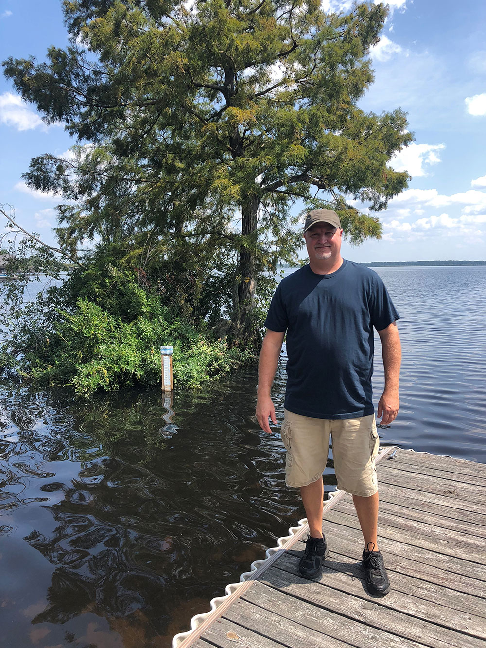
That citizen scientist, Darren Kelly, turned out to be the first of what Parkins refers to as a “super user.” Since LOCSS began, researchers have found that more than two-thirds of the people who send in measurements only do so once or twice. But a handful of loyalists routinely send in updates — and that’s where most of their data comes from.
“I’m interested in science,” says Kelly. “I went out to the lake to fish one morning and saw the sign. It piqued my interest, so I decided to send in a measurement. Then I started doing a lot of them. I would go down there, check the gauge, and send a measurement every day.”
Bay Tree Lake is in a private community that borders state park land, and Parkins and Pavelsky worked with the park system to have the gauge installed. Because access to the lake is limited to residents and state park staff, Kelly is a crucial part of LOCSS. And the lake is a crucial part of Kelly’s life.
“My wife and I are empty nesters and I’m semi-retired,” Kelly says. “I boat and fish and just generally spend a lot of time outside by the water.”
Kelly has presented to his homeowners association about the project, forged community connections for Parkins and his team, and is even listed as a co-author on a peer-reviewed publication about the study. Super users like Kelly have helped maintain LOCSS’ presence at existing lake sites and expanded it to other states and countries.
“We were able to prove our concept of a citizen scientist-backed program that relies on a desire from the general public to understand natural resources important to them,” Parkins says.
When the funding for the pilot project ran out in 2018, Pavelsky and Parkins took their proven program back to NASA with the intention of augmenting another project Pavelsky had been working on with the space agency since 2004.
The Surface Water and Ocean Topography (SWOT) Mission will produce the first global survey of Earth’s surface water. The project is using data collected by a satellite to track changes in water movement and volume across the planet. Since the SWOT mission is the first of its kind, researchers must validate the satellite’s measurements by taking their own on the ground — a perfect fit for LOCSS and its citizen scientists.
Since receiving funding from NASA, LOCSS has grown to monitor more than 200 lakes across four continents. Researchers work with partners in each location to maintain gauges and retrieve data that is used to not only validate SWOT satellite readings but inform communities about changes in their local resources.
“We choose lakes that are locally important,” Parkins says. “The data we get from LOCSS can be foundational to our partners, giving them information on seasonal trends and the hydrologic cycle in their region. Whether they’re avid fishermen or worry about receding shorelines near their homes, they have a better understanding of what’s happening.”
As LOCSS has expanded, the heart of the project remains the same: education and engagement. Each person who sends in a lake level measurement provides a valuable service and learns something in return. And super reporters like Kelly keep the study afloat.
“To contribute to something a lot of smart people are studying and see some outcomes is pretty neat,” Kelly says. “I’ll keep supporting the project for as long as it lasts.”
Grant Parkins is the watershed education coordinator at the Center for Public Engagement with Science in the UNC Institute for the Environment. He oversees the Lake Observations by Citizen Scientists and Satellites program.
Tamlin Pavelsky is a professor in the Department of Earth, Marine, and Environmental Sciences within the UNC College of Arts and Sciences and the hydrology science lead on NASA’s Surface Water and Ocean Topography Mission.
Darren Kelly lives in Bladen County, N.C., and is a longtime citizen scientist volunteer for the Lake Observations by Citizen Scientists and Satellites program.